
| EURAC, European Academy Bolzano |
| AMGI, Anton Melik Geographical Institute, Ljubljana |
| CEMAGREF, Grenoble |
|
Background
Between 2004 and 2008, the INTERREG IIIb-project DIAMONT has collected a huge amount of information. To allow its easy access, use, documentation and further exploitation by local stakeholders, the project results are stored and publicly available in an online database.
The database provides information about the status of municipalities in manifold fields of development, and allows stakeholders to carry out benchmark analysis for their respective municipality in comparison to other municipalities across the Alpine Convention area. It is dedicated to support sound and transparent decision-making on regional and local level based on statistical data and a transnational collection of regional development instruments.
Conceived with the steering bodies of the Alpine Convention, the database represents a vital impulse to the relaunch of SOIA, the System for the Observation of and Information on the Alps, and its newly designed objectives.
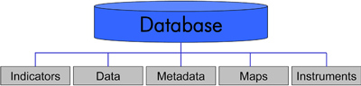
Database structure
The database is structured in "classes", which refer to central deliverables of the DIAMONT project including indicators, data, maps and instruments, and metadata documentation on the presented indicators, data and maps itself.
Please follow this link to access the database.
![]()
Follow this link to the Alpine Convention's Report on the State of the Alps on Transport and Mobility (available in en, it, fr, de, sl)
